Flying in Hampton Roads is not so easy
As I have mentioned before, because of the local airports and military bases, around 60 percent of Hampton Roads is restricted..
Flying in Hampton Roads is not so easy
Sunday December 15th 2024 - 10:17 AM ESTBy: Air Aspects
As I have mentioned before, because of the local airports and military bases, around 60 percent of Hampton Roads is restricted airspace, and so legally you cannot just "take off and get photos".
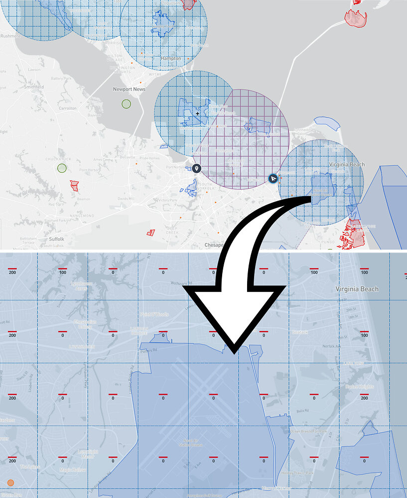
For example, Oceana's airspace covers most of Virginia Beach, from the oceanfront to almost Town Center, and a lot of that area is completely restricted (the blocks with '0' in them), so you're not even allowed to take the drone up 5 ft without getting permissions.
Where Oceana�s airspace ends, Norfolk International Airport�s airspace begins, covering most of Norfolk from Ocean View down to Waterside. Again, several parts of that area are �zero blocks�, meaning you cannot legally take off at all without jumping through a few hoops.
After that, with Naval Station Norfolk, Langley, Fort Eustis and Newport News/Williamsburg Airport, restricted airspace covers the Peninsula up to around Yorktown.
When flying in an FAA controlled airspace, such as Norfolk International Airport, permissions can sometimes be obtained through the LAANC - Low Altitude Authorization and Notification Capability - system. If you want to fly higher than that location block allows, you have to apply a few days out.
Some of this preparation can take a few days, depending on the exact location, time of day of the shoot, and length of the job.
This is why professional drone pilots like me often need at least a week�s notice when being asked to take aerial photos, even for a small real estate shoot.
Having such notice gives us time to get our ducks in a row, and gives time to plan the shoot for a nice day, so the photos turn out their best. Also, this planning enables the task to be carried out legally and avoid possible fines, not just for the pilot but also for the person hiring them.
Several things have to be considered when you�re using aerial photos and video to promote yourself. This is where an experienced, licensed and insured photographer can really make you stand out from the crowd.
Tags: Advertising | Published Columns
Aerial Photography Projects
Aerial photo shoot of a lot in Gloucester, VASunday June 14th 2026
Aerial Shoot for Chesapeake Home
Sunday June 07th 2026
Tourism in Tennessee and North Carolina
Wednesday June 03rd 2026
Aerial shoot for Suffolk commercial lots
Monday May 11th 2026
Suffolk Aerial Shoot for a Grand Opening
Saturday May 02nd 2026
Aerial Suffolk Construction Project Coming Along Nicely
Tuesday April 21st 2026
Another Aerial Construction Shoot in Suffolk
Sunday March 22nd 2026
New aerial photography project in Smithfield
Saturday February 21st 2026

Contact Us
If you would like more information, please feel free to contact us by either phone or email.